In Trail 66, we return to the Bedfordshire and Northamptonshire borderlands to visit the site of another former bomber airfield that has been almost entirely erased from the landscape. Although its wartime service was relatively brief, it was defined by intense operational pressures, loss, and remarkable acts of heroism.
Despite continuing in use well into the Cold War and beyond, the airfield failed to leave the regional mark it deserved. Over time, its purpose changed and its structures were gradually removed, the land being adapted to modern energy use, leaving little visible evidence of its former importance. This transformation stands in contrast to the role the station once played and the legacy it holds today.
Home to a small number of RAF units, it was predominately an American base during the Second World War, and remained with them into the depths of the Cold War. Although flying activity ceased in 1962 with the departure of the modern United States Air Force, a military presence remained there until the Ministry Of Defence (MOD) sold the site as recently as 2005.
Whilst some aspects of the original airfield do remain, the vast majority has been decommissioned and removed, including the runways, works buildings and training facilities, leaving little more than ghostly evidence behind.
In this part of our trip to Northants and Bedfordshire, we visit the former RAF Chelveston.
RAF Chelveston (Station 105).
RAF Chelveston (Station 105) lies across the two counties of Bedfordshire and Northamptonshire, and although the border crosses roughly through the centre, the majority of the site lies in Northampton. Like many wartime airfields it went through a series of name changes depending upon who owned it at the time. Today it is known as Chelveston Renewable Energy Park, reflecting its modern use as the ‘centre of technological innovation’ capable of producing enough electricity, to power 60,000 properties.*1
During the planning stages in 1940 the aerodrome site was briefly referred to as Shelton, after the nearby village to the east. Before the station officially opened in 1941, however, the name was changed and it entered service as RAF Chelveston, the official British designation. Later in the war the airfield passed into American control and was designated Station 105 by the United States Army Air Force. Over the years though, it was also referred to as RAF Station Chelveston, and simply Chelveston Aerodrome, reflecting both its early planning name and the variety of roles it fulfilled throughout its operational history.
The land upon which the airfield sits, lies approximately four miles to the east of Rushden and about twenty-seven miles south-west of Peterborough. It shares a region – designated by a Peterborough, Northampton and Bedford triangle – with a number of other former bomber airfields including Kimbolton, Thurleigh and Molesworth.
The land for Chelveston (a name derived from a Norman family) was acquired by the Air Ministry in 1940, with construction beginning shortly afterwards. The airfield was initially intended for the RAF and the reformed 8 Group, with Taylor-Woodrow Ltd serving as the main contractor. At first, it had grass runways and minimal storage, consisting of a single ‘J’-type brick-and-metal hangar measuring 300 ft by 151 ft. Later, two ‘T2’-type metal hangars were added, each 240 ft long, 115 ft wide, and 29 ft high. The original design fell under development scheme ‘M’ of the Government’s expansion programme, which essentially replaced the earlier ‘C’-type hangars with the newer ‘J’-type. Since construction began during the war rather than before it, accommodation sites were dispersed away from the main airfield site – unlike pre-war designs, where living quarters were typically located on-site.
At Chelveston, these accommodation sites were positioned to the south-west of the airfield, unusually close to the main runway’s flightpath – in-fact within just a few hundred feet of its threshold. In all there were twelve accommodation sites, supplemented by two sewerage sites, giving a total of fourteen in all. These accommodation areas included: two communal sites, officers’ quarters, enlisted men’s quarters, sick quarters, and a large WAAF area with its own sewerage facilities.
The all important technical area, lay directly across the dividing public road from here; a little further north than the accommodation area and on the western side of the main airfield. It included a wide range of buildings including: MT (motor transport) sheds, operations blocks, briefing rooms, link trainers, stores, flight offices, works offices and the like.
Typical of the range of buildings found on any wartime airfield, they were a mix of both temporary and permanent construction. The manufacturers involved were also typical of those pertaining to wartime airfields: Laing, Romney, SECO, Ministry of Works and Nissen, who used a variety of construction materials including timber, iron, plasterboard, brick and concrete to create these various standard design structures.
On the main airfield itself, No. 1 runway ran north-east to south-west, whilst No. 2 dissected it in a north-west to south-east direction. The third runway, No.3, ran just off north to south. The classic ‘A’ frame was created by the crossing of all three in the centre of the airfield with the runways extending extensively beyond this point. As in all cases, the three runways were linked by a circular perimeter track, around which eventually, some fifty-five hardstands were built; both a mix of ‘spectacle’ and ‘frying-pan’ types.
As with all airfields of its kind, a bomb store would be incorporated well away from the accommodation and technical areas, and in Chelveston’s case this was just off to the north-east. Here, a number of hardened shelters were interlinked by small tracks along which the bombs were transported to the various aircraft dispersals.
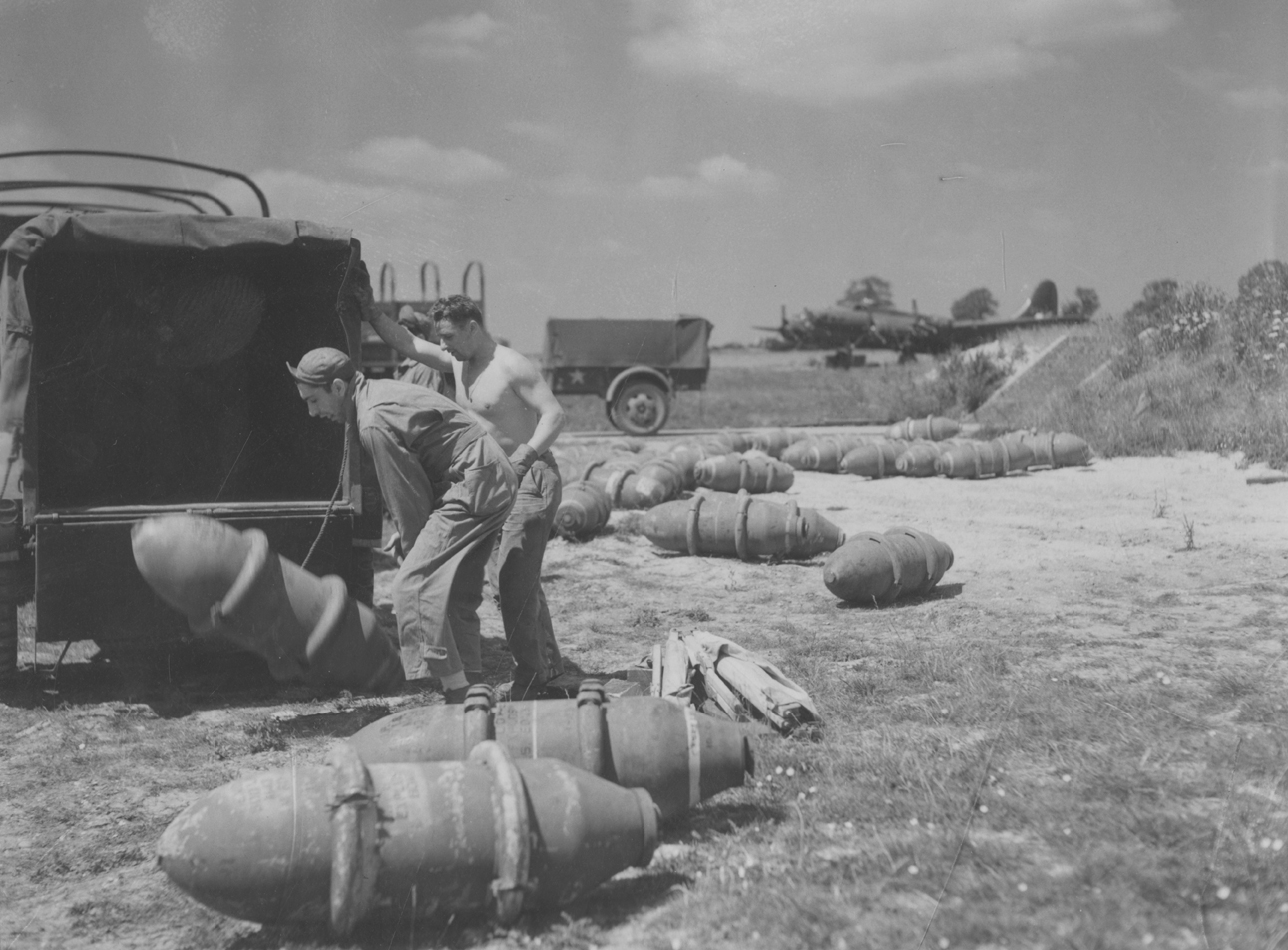
Bombs being man-handled at Chelveston. (IWM FRE10440).
Overseeing movements in and out of the airfield was the watch office, which stood proud with clear views across the airfield. Located to the western side of the site, the office was built to drawing 518/40 – the largest and most common wartime design. This particular build evolved from the 1939 drawing, number 5845/39, and incorporated the meteorological office within its layout. By combining both functions into a single structure, it enabled the rapid exchange of vital weather information.
Chelveston’s construction began in 1940 on land straddling the Bedfordshire-Northamptonshire border. A basic airfield to start with, it soon began to develop and grow, all part of Britain’s rapid wartime airfield expansion programme. Over the next few months it would grow and develop into a standard three-runway bomber airfield complete with dispersals, technical buildings, bomb stores and extensive accommodation sites. Though the landscape has since been transformed into the modern Chelveston Renewable Energy Park, the wartime layout still hints at the scale and ambition of the original station.
The story of how this quiet stretch of countryside evolved from construction site to operational wartime airfield begins in Part 2, as RAF Chelveston opens its runways and the station starts its journey toward becoming an important Allied base.
The whole story of Chelveston can be read in Trail 66. Northants and Bedfordshire (Part 2)
