Dunsfold seek Designation for a Conservation Area

As previously mentioned, Dunsfold airfield has been the subject of a planning proposal and it has been brought to my attention that this has now gone through. Permission has being granted for the construction of some 1,800 homes. However, in order that some of the buildings can be saved, the Dunsfold Airfield History Society are seeking designation of the site as a conservation area.

In addition to this, Historic England are also looking at listing 10 of the buildings on the site, thus protecting them for future generations, and together, these moves may help save some of these historic features before it is too late.

You can help by registering support as soon as possible on the  on the Dunsfold Airfield History Society site at:
https://dunsfoldairfield.org/conservation-area/

Waverley Council have produced a map showing the extent of the site and the proposed conservation area.

A New Memorial to Honour Those Who Never Came Home.

RAF Downham Market in Norfolk, was home to 6 squadrons during the Second World War: 214, 218, 571, 608, 623 and 635 along with a number of other non-flying units. It was also home to a number of aircraft types, Short’s enormous Stirling, the famous Lancaster and of course de Havilland’s ‘Wooden Wonder’ the Mosquito of the RAF’s Pathfinder force.

RAF Downham Market

One of the many huts still left on the airfield.

It was also the airfield that launched the last bombing mission by an RAF aircraft, a Mosquito, on May 2nd 1945, to attack retreating German forces at the Kiel canal.

Considering the strong links it has with the RAF and Bomber Command, it has never been given a fitting memorial, but maybe finally, this is about to change.

A proposal has been put forward to erect a grand memorial on a site next to where one of the former accommodation sites once stood. It will honour not only those who flew from Downham Market and never returned, but those who served and were stationed here as well.

It is hoped that the new memorial will consist of seven polished, black granite slabs with each name of the 700 crewmen who lost their lives, carved into it, in the order in which they were lost. It is hoped to raise £250,000 to cover the cost of the structure which will be grand in scale and stand next to the main A10, a road that was made using the runways for its hardcore.

Currently the only reminder of their sacrifice is a small memorial outside of Bexwell church. It is a small memorial telling the stories of the two heroic crew members, Flight Sergeant Arthur Louis Aaron and Squadron Leader Ian Bazalgette, two pilots who both received the Victoria Cross whilst at Downham Market, for extreme bravery in the face of the enemy.

Today whilst none of the runways or perimeter tracks exist, a number of the original buildings are still present, used by small businesses and light industry. Recently however, a  £170m regeneration plan was announced, one that may signify the end of these buildings and Downham Market airfield for good (see here).

RAF Downham Market and especially the many crew members, who came from all across the Commonwealth, deserve great recognition for the work they did. Perhaps this, is finally a sign that it may now happen.

The full story and pictures can be accessed on the Eastern Daily Press website. There are more details and a link to the donations page on the RAF Downham Market website. 

RAF Downham Market appears on Trail 7 – North West Norfolk. 


RAF Cottam – Built and Abandoned.

Up in the Yorkshire Wolds stands an airfield that could have been considered as one the Air Ministry’s ‘less sensible’ decisions. Open to the elements, this site was built but never fully used by an operational flying unit, in fact, Cottam could be considered one of the RAF’s more expensive bomb dumps, used primarily for munitions storage toward the war’s end. In its construction it would have accommodation, a hangar, and a watch office, along with three concrete runways – all the makings of an RAF bomber base, yet it was often desolate and empty. Even though it wasn’t used operationally, it did have its own problems however, and its own casualties . As we head across the River Humber into the East Riding of Yorkshire, we visit the former RAF airfield, RAF Cottam.

RAF Cottam.

Designed originally as a satellite for RAF Driffield, Cottam airfield lies high up in the hills on Cottam Well Dale, about 5 miles north of Driffield, just a stones throw from the village of Langtoft, and the tiny parish of Cottam. At 475 ft. above sea level, it is one of the higher peaks in the area which makes it popular with dog walkers and ramblers alike.

The airfield site encompasses the site of the ancient village of Cottam, (on maps of the late 1600s it appears as Cotham) of which only the church remains.  A lone building, it stands neglected and derelict, a reminder of a small community that has long since gone.

RAF Cottam (Yorkshire)

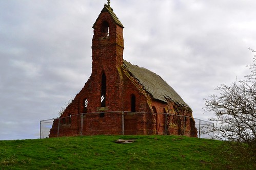
The abandoned medieval church marks the boundary of Cottam airfield and a community long gone.

The Air Ministry decided to build an airfield here to be used as a satellite and possible bomber base. The airfield would have a watch office with detached operations block (the separate block designed to drawing 13023/41). As construction was completed before June 1941, it would be classed as a Type ‘A’ building, and would need to be modified to bring it up to the newer Type ‘B’ standard as were being built on later airfield sites. Under the Type ‘B’ scheme, Cottam would have a Watch Office built to design 13726/41, then adapted by the fitting of smaller ‘slit’ windows more in line with bomber and O.T.U. satellite airfields of that time (15683/41). Sadly, the entire building was demolished in 1980, and no there are no signs of its existence left on site today.

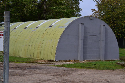
A single T1 hangar provided space for aircraft repairs and maintenance, and accommodation, although sparse, would accommodate around 1000 men and 120 women of the Maintenance Command by December 1944.

RAF Cottam (Yorkshire)

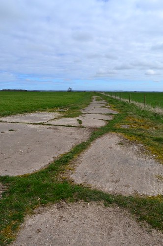
The remains of the secondary runway looking west.

Cottam officially opened in September 1939, and as a grassed airfield, would only be used for dispersed aircraft from Driffield’s 4 Group Bomber Command, flying Whitleys of 77 and 102 Sqn. Cottam was also used later on for the Fairy Battles of 4 Group Target Towing Flight (4G T.T.F.) also based at Driffield at that time.

It wouldn’t be long though before Cottam would have its first accident. On July 1st 1940, a dispersed aircraft, Whitley V, (N1391) ‘DY-H’ of 102 Sqn, swung on take off causing minor damage to the aircraft. Luckily there weren’t thought to be any casualties in the incident, but the aircraft was rendered unable to fly, and the damage was sufficiently serious to need it to be taken away for repairs.

A month later, the 15th August 1940, signified a major point in the Battle of Britain, one which saw all of the Luftwaffe’s air fleets deployed for the first time, in a full and coordinated attack on the British mainland. This day saw the heaviest fighting of the Battle with attacks ranging from the south coast to east Yorkshire, and up to Edinburgh. This also meant the start of a number of attacks on British airfields and Driffield would not be left out. In this first attack, a Luftwaffe force of some 50 Junkers Ju 88s attacked the airfield damaging or destroying 12 aircraft on the ground – many of these were Whitleys. This attack was particularly devastating for a number of reasons, one of which was that it caused the first death on active service of a Bomber Command W.A.A.F., (A.C.W.2) Marguerite Hudson, who was killed after delivering stores to the site. This attack caused extensive damage to both the airfield site, infrastructure, and aircraft, and for a short period whilst repairs were undertaken, some aircraft were moved and dispersed here at Cottam. Indeed, on 27th September 1940, 4 Group T.T.F moved over to Cottam where they stayed for a month, not returning until the 24th October, once repairs had been completed and air attacks had all but ceased.

RAF Cottam (Yorkshire)

The secondary runway looking east, this part is full width but built upon.

It is possible that these attacks may have led to the demise of one 77 Sqn Whitley V (N1355) ‘KN-X’ flown by Sgt. James Walter Ward RAFVR (741435), who undershot on landing at Cottam, hitting a fence, causing the undercarriage to later collapse. The five occupants of the aircraft were unhurt, but the aircraft itself was later struck off charge on 22nd September 1940, after assessment at Armstrong Whitworth in Baginton*1. Ward himself was killed with his crew only five days later, when his aircraft, Whitley V, (N1473) was shot down by flak over Noord Brabant, 2km from Vijfhuizen, on September 25th 1940. He died along with P/O C. Montague, himself a veteran of three previous serious crashes.

By the end of August 1940, both 77 and 102 Sqns had departed Driffield and so Cottam, which left it only being used by the Fairy Battles of 4 G T.T.F. During the winter months Cottam was abandoned by these aircraft, presumably due to its inclement weather conditions, but dispersed aircraft did return again in the spring and summer months. In October 1941, 4G T.T.F. reformed at Driffield as 1484 T.T.F., and it is at this point that it is thought their use of Cottam ceased.

RAF Cottam (Yorkshire)

The perimeter track looking east. The main airfield is to your left.

Under the Ministry’s airfield expansion plan, new airfields of the early 40s were built with concrete surfaces. ‘Older’ grass sites, like Cottam, were upgraded having new runways laid down in an effort to reduce water logging and provide a more stable surface for the heavier bomber aircraft coming in. To meet these upgrades Cottam’s three runways – all consisting of concrete and wood chip – were built; the main being just short of 5,300 ft., with the two further runways around 4,000 ft. in length. Pan style aircraft dispersals were also added which gave Cottam a new look and hope for the future. However, and even though huge amounts of money had been spent on the airfield, it was decided it was not to be used further, as either a satellite or a bomber station. Cottam was offered to various other military groups who all turned down the location for various reasons. The army did take up residency for a short while until March 1944, whereupon it was then used to store vehicles for the impending invasion of Normandy.

RAF Cottam (Yorkshire)

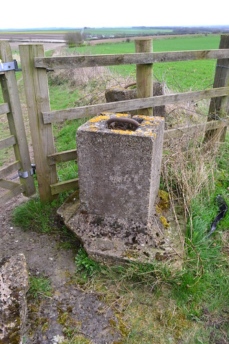
Blocks from the former site, and the beautiful views across the Wolds from one of the highest peaks in the area.

It is believed that further forced landings took place at Cottam during this time. Firstly, a damaged B-24 ‘Liberator’ came down after sustaining damage on a raid; and secondly, it is also thought that a Halifax landed here after an S.O.E. mission. Sadly at present, I can find no further official details of these events, and cannot therefore expand on them further.

Toward the end of the year 91 Maintenance Unit (M.U.) were based here*2 using the runways and hardstandings to store ammunition and other stores that were delivered by road from the rail yard at Driffield. A spell of residency for 244 Maintenance Unit carried on the storage work before the airfield was finally abandoned and closed in June 1954.

Returned to agriculture, the airfield is mostly gone, a section of the easy-west runway does still exist, and in part, at full width. Footpaths allow for walks across the site allowing views along the runway in both directions, they also allow walkers to use the remains of the perimeter track and secondary runway – albeit as a track. The frame of an air-raid shelter and the standby set house (designed to drawing 13244/41) are in situ, although by far the runways are the most prominent feature surviving today.

Access is best made from the Cottam Lane junction. The path leads up through the site of the medieval village of Cottam where the church still stands. This takes you south onto the airfield site itself and along the two runways. The walk extends along the perimeter track to the south, where debris from the perimeter track can also be seen.

Built high on the Wolds of Yorkshire, it is hard to understand why such a site was chosen. In winter, it could be bleak, windy and very cold. Landing conditions must have been difficult at best, and treacherous at worst. Its history of accidents tell their own tale.

In 2016, Cottam Airfield was the subject of a wind farm review, and a battle between the locals and the energy firm R.W.E, began. As yet though the site remains free of turbines, a gem for walkers and those wishing to experience the natural beauty of the Yorkshire Wolds. The open air and fabulous views hide a strange history, one that goes back long before the Second World War, but one that has only scars to tell the tale in this oddly historical, but beautiful part of Yorkshire. *3

Source and further reading:

*1 This was reported on a number of sites (Air Safety Network) but no records could be found referring to the accident in the Operational Records Book recorded by 77 Squadron at that time.

*2 See the National Archives website for details.

*3 News report on the proposal.

The Hull and East Riding at War Website has a range of information on the area during the Second World War.

My thanks go to Ronnie and Jo for the great walk, and for being such fabulous hosts. 

P/O J. A. Philpott – RCAF Log Books

These books were kindly lent to me to read, they are the service records of P/O J. A. Philpott (1312948) of the R.C.A.F.

They are four in total and cover a period from September 1941 to November 1945. I shall read them and share some of the records later. These were kindly lent to me by his grandson to whom I am very grateful.

P/O J. A. Philpott - Log Books

P/O J. A. Philpott - Log Books

P/O J. A. Philpott - Log Books

P/O J. A. Philpott - Log Books

RAF Martlesham Heath (part 2) – A long and distinguished history.

In part two of this Trail, we continue looking at the history of RAF Martlesham Heath.

RAF Martlesham Heath (Station 369).

On August 15th 1944, two P-47s flying more than 200 miles off course mistakenly attacked the Ninth Air Force headquarters near to Laval. In the attack, ground gun crews managed to bring down one of the aircraft killing its pilot. The second aircraft managed to avoid the anti-aircraft fire and returned home safely.

For three days in September, the 356th attacked enemy gun emplacements at Arnhem, earning themselves a DUC for their actions. These aircraft had the unenviable task of attacking the gun emplacements defending the allied drop zones. In order to neutralise the guns, the pilots first had to find them, a move that involved presenting themselves as bait. They proved their worth, bombing and strafing with 260lb fragmentation bombs, destroying all but two of the guns.

Former RAF Martlesham Heath

Martlesham Heath’s Watch Office now a museum surrounded by housing.

In November 1944 the P-47s were replaced by the P-51 ‘Mustangs’, the delight of the USAAF Fighter Groups. Early successes were good, even though they were tainted with repeated and wide-spread gun jamming.

The winter of 1944-45 was notoriously bad, one of the worst on record and many flights were cancelled at the last-minute. Maintenance on open airfields was incredibly difficult and accidents increased because of cloud, ice and snow. In mid January, five P-51s were lost, crashing on snow packed runways, being lost in cloud or suffering from taxiing accidents. By now though the war had turned and the blue and red chequered nosed fighters of the USAAF had turned to hunters and were eager for blood.

By now, Luftwaffe jets had now been in service for some time, harassing bombing formations, diving in amongst them, firing and then fleeing. Three P-51s of the 356th had the good fortune to catch an Arado-234 in the Bielefield area. After the pilot bailed out, they flew along side photographing the aircraft before finally shooting it down. It was one of a number that day that were lost to American airmen.

As the war ended the 356th had seen only eighteen months of active service, a short time that had allowed them to amass 276.5 kills in the air. Whilst being the lowest ‘score’ in the US Air Force, it doesn’t detract from the determination nor the skill of the brave pilots who flew with the 356th.

After the war’s end, the Americans departed and in November 1945, Martlesham Heath was returned to RAF ownership.

In 1946, experimental units returned with the forming of the Armament and Instrument Experimental Unit. Over the next few years they would go through several changes of name , but in essence retained their primary role. During this period, they would operate a small number of aircraft including amongst them: Mosquito NF38 (VT654); Meteor F4 (VW308); Lincoln B1 (RE242); Canberra T4 (WE189) and Comet 3B (XP915).

On November 1st 1949, the Bomb Ballistic Unit (formed May 1944 at Woodbridge) and Blind Landing Experimental Units (formed October 1945 also at Woodbridge) were amalgamated, forming one complete unit (the Bomb Ballistic and Blind Landing Experimental Unit) here at Martlesham Heath. They each operated a number of twin and four engined aircraft that would be absorbed into the Armament and Instrument Experimental Unit 15 days later. On November 1st 1955 RAF control of the unit ceased, and it was re-branded Armament and Instrument Experimental Establishment, whereupon it ran until 1st July 1957, when it was disbanded and absorbed into the Royal Aircraft Establishment.

Former RAF Martlesham Heath

A number of the ‘H’ blocks have been given a new lease of life as office blocks. The parade ground, the car park.

With little operationally occurring at Martlesham, its decline was inevitable. Between 15th April 1958, and New Years Eve 1960, 11 Group Communications Flight operated: two Ansons (TX193 & WB453); a Devon (VP974); a Meteor T7 (WL378) and Chipmunk T.10 (WG465). Following their disbandment the only other flying units to use Martlesham were the then Hurricane and four Spitfires of the Battle of Britain Flight (now the legendary Battle of Britain Memorial Flight based at RAF Coningsby) between 1958 and 1961. The 612 Glider School also used the site between September 1952 and May 1963, whereupon they disbanded and the airfield then closed. Remaining intact, the airfield would continue to be used but for light private flying only, until this also finally ceased in 1979.

Following its closure, Martlesham Heath’s 600 acres were handed over to the Bradford Property Trust following the reversion of the lease from the Air Ministry, and because of its location to both the larger town of Ipswich and the major sea port at Felixstowe, it was destined for development. It was declared by the new owners that Martlesham would become a ‘village’, rather than a traditional ‘housing estate’ in which the concept of small groups of housing would be built, often around a cul-de-sac rather than in rows, thus promoting a ‘community spirit’ within each segment of the development. Planning permission was granted in 1973, ten years after the Ministry sold it off, the development was finally completed in 1990.*2

On its completion Martlesham was designated a village, and since then the original 3,500 population has grown, in 2011, the Martlesham Neighbourhood Development Plan stated the population of the Parish at 5,478.

Today Martlesham Heath is a thriving mix of private housing, industrial and retail units, reflecting this ‘Garden Village’ design. Two major employers soon moved in: the British Telecom Research Centre and Suffolk County Police – forming their headquarters on this and the adjacent land.

Beneath all this development though, elements of the ‘Heath’ do still exist, largely due to the good foresight of the developers. The parade ground (now a car park), the barrack ’H’ blocks (like West Malling are office blocks), the watch office, messes, hangars and RAF workshops all transformed into light industrial units which remain in use today.

In 1982, local people set on preserving the heritage of Martlesham Heath created the Martlesham Heath Aviation Society, and were allowed to set up their home in the former watch office. After raising funds, the office was refurbished and turned into a museum displaying many artefacts, stories and photographs of Martlesham’s history. The museum finally opened in 2000 and remains there today encircled by housing on all four sides. The spirit of Martlesham Heath also lives on in the road names. Even the Douglas Bader pub has a tenuous link to this historic place.

Former RAF Martlesham Heath

The memorials to those who served at Martlesham Heath during its long and distinguished career.

Viewing the airfield remains are relatively easy as most are visible and accessible from the public highway. Finding them is another matter. The design of the streets are such that there are many paths and small side streets and ‘getting lost’ is quite easy for the visitor. The main A12 road through Martlesham dissects the airfield site in two. The museum is to the west off Eagles way, surrounded by housing – an odd remnant of a bygone era. What little remains of the runway can be seen further south off Dobbs lane, in an area of heath and scrub – a lingering reminder of this once historic airfield, how long I wonder, before this too is removed.

The hangars and barrack blocks are to the eastern side, mostly among the retail park. The three memorials are located on Barrack Road opposite the BT building and alongside the former parade ground and ‘H’ blocks.

Now listed locally and with Suffolk Coastal District Council, many of the remaining but obscure remnants (airfield markers, hangar foundations, revetments, and the last remains of the runway) all lie dormant amongst the footpaths, cycle tracks and parks of the huge Martlesham Heath conurbation that was once RAF Martlesham Heath.

Notes and further reading

*2 Ward, S.V., The Garden City, past, Present and Future,  1992, Spon Press